The Science Behind Windstorms: Understanding Pressure Gradients
Windstorms can strike unexpectedly, often manifesting as powerful gusts that can span hundreds of miles or affect local neighborhoods. Regardless of their scale, they share a common cause: fluctuations in air pressure.
Understanding Pressure and Wind Formation
Air in our atmosphere behaves similarly to air escaping from a deflated tire: it moves from areas of high pressure to areas of low pressure. The greater the difference in these pressure levels, the more intense the winds will become. This phenomenon, known as a pressure gradient, is the foundational principle behind wind formation.
Origins of Pressure Gradients
Pressure gradients are primarily influenced by the Earth’s spherical shape and its rotation. The solar energy received at the equator is more intense than at the poles, leading to warmer temperatures and higher pressure in the tropics. This imbalance triggers air movements as nature seeks to equalize these differences.
High-altitude winds, such as the jet stream, are generated in midlatitude regions, significantly impacting surface winds. These jet stream winds predominantly flow from west to east, and they play a critical role in shaping weather patterns across the continental United States.
The Role of the Jet Stream
The jet stream’s meandering can create diverging air leading to lower surface pressure, giving birth to what meteorologists recognize as extratropical cyclones. Conversely, merging air masses can lead to the formation of high-pressure systems, establishing the conditions for varying wind patterns.
Consequences of Pressure Differences
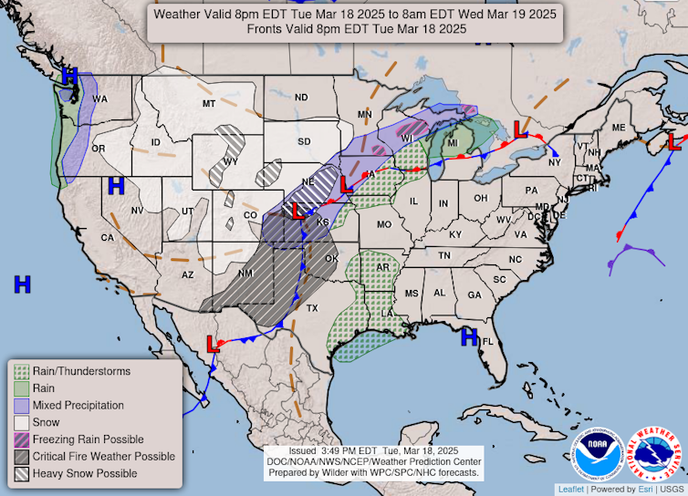
The interaction between these high and low-pressure systems creates distinctly windy conditions. Winds tend to spiral around these areas; they rotate clockwise around high-pressure zones and counterclockwise around low-pressure regions. The resulting pressure gradients can cause widespread meteorological events, including dust storms and wildfires.
Springtime Winds and Their Impacts
In spring, the differences in temperature are especially pronounced, leading to more intense pressure systems. These winds can be particularly strong in flat, open areas like the Great Plains, increasing the likelihood of dust storms and creating severe fire risks during dry conditions. For instance, arid regions in Texas and New Mexico are particularly vulnerable to these wind-driven phenomena.
Extreme Weather Events: Tornadoes and Thunderstorms
While broad-scale windstorms can be significant, localized phenomena such as thunderstorms can lead to even more intense winds. Thunderstorms may produce downdrafts that result in straight-line winds extending over large areas. In extreme cases, these conditions can foster derechos—powerful windstorms characterized by widespread damage.
Additionally, the conditions conducive to tornado formation typically involve a sharp pressure gradient. The low pressure at a tornado’s core can result in extraordinarily high wind speeds, sometimes exceeding 300 mph in the most severe tornadoes.
Interconnected Weather Systems
Interestingly, the same jet stream wave that causes robust wind activity may contribute to varied weather experiences across regions. While one area may face dust storms potentially leading to wildfires, another might experience severe thunderstorm outbreaks and even blizzards, thanks to the complex interactions of atmospheric systems.
Conclusion
Windstorms are a fundamental aspect of our weather system, driven primarily by pressure gradients arising from temperature differences across our planet. Understanding these phenomena allows us to better prepare for and respond to the diverse impacts they generate—whether that be dust storms, wildfires, or severe storms like tornadoes.

